By Fred Scatena and Bill McDowell
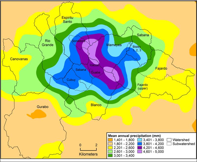
The Luquillo Mountains have a warm and humid subtropical maritime climate. Mean monthly temperatures at lowest elevations range from ca. 23.5°C in January to 27°C in September, and at the highest elevations from ca. 17°C to 20°C in those same months. The amount of daylight varies only about 2 hours during the year, with the longest day having about 13.2 hours and the shortest day about 11.0 hours. Prevailing easterly trade winds coming off the ocean drop rain as they rise over the mountains; thus rainfall increases with elevation, ranging from an average of 3537 mm year-1 at low elevations to 4849 mm year-1 higher up (Figure 1). The Luquillo LTER is the warmest and wettest of the LTER sites. The LEF peaks also receive additional water from cloud drip as clouds pass through the vegetation and condense on leaves. This cloud drip can be as much as 10% of mean annual rainfall. Although dust from North Africa and anthropogenic pollutants from the Northern Hemisphere occasionally enter the region, the area is known for the chemical purity of its rainfall.
Within the Luquillo Mountains rain and runoff occur in every month. However a drier period typically occurs between February and April, and wetter periods occurs from September to December. More than 1000 rain showers occur every year and are associated with the cooling of on-shore breezes, local thunder storms, hurricanes and tropical waves, and weather systems that originate in northern temperate areas. Annual and seasonal rainfall, as well as hurricane frequency, has been correlated with El Nino activity, water levels in African lakes, Saharan rainfall, and surface and subsurface sea temperatures.
On average, a major storm affects Puerto Rico every 14 months. The majority of these storms occur during the summer months. Hurricanes are the most damaging type of storm and the dominant natural disturbances affecting the Luquillo Mountains. Every year several hurricanes pass through the Caribbean region and bring some rain to the island. Once every 10 years a hurricane will typically pass close enough to the island to cause severe but localized damage. Once every 50 to 60 years a hurricane will pass directly over the Luquillo Mountains and cause widespread damage to the forest (see article Disturbance and Recovery in this web page).
Nine rivers have their headwaters in the Luquillo Mountains (see Streams). The morphologies of these streams reflect the interactions of tectonic movements, periodic high-magnitude floods, and a plentiful supply of coarse bedload. At lower elevations outside the forest, stream channels typically have high-flow channels, multiple depositional surfaces, and relatively wide valleys. Within the Luquillo Experimental Forest (LEF), streams typically flow in steep, bedrock- and boulder-lined channels within narrow valleys. Waterfalls and bedrock channels are common. Headwater channels typically are tree lined and have pools with depths less than 0.75-1.0 m. Second and third-order tributaries have relatively open canopies and depths usually less than 1 m.
Stream discharge is highly variable, and ten-fold increases in discharge have been recorded within an hour. The lowest stream flows during the year usually occurs in March, April or July. The highest daily stream flows usually occur in May or September. Water temperature in headwater streams is relatively consistent throughout the year and ranges between 18° and 24° C. The average pH of stream water is 7.2 but ranges between 7 and 7.7.
Currently, over 30 water intakes exist on streams originating within the LEF. These intakes typically consist of small (< 3m high) dams that supply gravity-driven water distribution systems. Approximately 30% of the stream water draining the forest is appropriated annually for municipal use. However, because most water leaves the forest during short duration high flow events, on an average day over 50% of the stream water draining the forest is removed before it reaches the ocean.